6th February 2011
A short Munro bagging expedition from the fabulous Glen Lyon
Meall Buidhe (932m) - Miaowl Vooyer "Yellow Hill"
This was my second trip out of the year, after spending a great New Year's day on Ben Vorlich with ice axe and crampons. Meall Buidhe is the sister Munro to Stuchd an Lochain at the western end of the glorious Glen Lyon.
Started out on Sunday at 8:30, the usual drive out through Doune and Callander and then along side Loch Lubnaig, which looked fine with a mirror calmness. The drive up over the pass by Ben Lawers was a tad hairy and there wasn't any hairy coos about this time. However, entering Glen Lyon is always a magical experience. It really has to be my most favourite glen that I've visited. I was parked up and walking by 10:20.
A group of 6 people were heading the same just ahead of me. I followed them up the initial climb, but realised they didn't know where the path was. I left them to it and picked the route steadily climbing up onto a ridge. Meall a' Phuill could be seen ahead and gave a good point to aim for keeping a northern bearing.
I was soon into large patches of snow. Crampons weren't required as the climbing wasn't steep and it was easy to kick steps when needed. Finally the ridge opened out onto a wide open area. I could see people making their way along the saddle between Meall a Phuill and the ridge to the summit, this was now my destination. Crossing the open country was fun, picking my way over tussocks and snow patches, often sinking almost to my knees into the snow. I finally made it up onto the saddle, bang on course at a small cairn.
From here it was a simple case of following the ridge up and round to the summit. An initial climb over a large snow patch was fun and if I had some more time it'd been the perfect spot to practice a self arrest with the ice axe. Once up on the ridge I found the first large cairn, turned north and carried on for another kilometre or so. By this time the visibility was very poor, walking in cloud. The temperature had dropped considerably, but the walking was easy and navigation straight forward. Now and then I got glimpses either side of the ridge, quite a plummet to the east, gentle to the west.
I could see the group that I'd spotted on the saddle earlier in front of me. They were at the summit. I reached there after 1hour 40mins. Pretty quick. Sadly there wasn't much of a view so a quick cup of hot choc' and a snack, a couple of photos and I turned to head back following the same route.
The walk back was easy and straight forward. I got a few more glimpses of either side of the summit ridge - some impressive snow formations to the eastern side. Once out of the cloud I got some better views to the south and started taking more photos. This was my first hike with the new camera, so there's still work to do there, but hopefully some arty black and white snaps to come. I was back at the car just over 3 hours later, bang on time according to the guide book. A perfect winter walk to get the legs stretched and the mind clear.
Sorry, no map or photos yet - working on that.
Stat's
Distance: 9.23km
Ascent: 672m
Time: 3:06
Munro Count: 1
Total Count: 19 of 283
Monday 7 February 2011
Thursday 28 October 2010
Carn Gorm
24th October
A walk cut short by the first winter weather of 2010.
Carn Gorm (1029m) - Karn Gorrum -"Blue Hill" (not to be confused with Cairn Gorm)

I've slowly been picking off the mountains in the Loch Tay / Glen Lyon area. With Sameshrie away for the weekend I had plans for a long day out picking off 4 peaks in one walk, starting with Carn Gorm from Glen Lyon. I had an early start for the 1.5 hour drive to Invervar. On entering the beautiful glen, fast becoming one of my most favourite corners of Scotland, I was greeted with stunning Autumn colours and a sign warning drivers to watch out for red squirrels. 500m down the road, as if on cue, said beasty scampered across the road and up a tree.

The small car park already had a couple of cars there and another arrived as I was getting my boots on. A couple of guys got out and kitted up. They set off in the same direction as myself up a leafy farm track through a forest and eventually out onto the open hillside. Soon after leaving the forest I had good views to the mountain tops that I had intended visiting later that day. All of them with a good covering of snow above about 800m. As I carried on up the valley the weather started to turn and it soon became time for full water proofs. This is where I made a bit of a navigational mistake as I missed the river crossing to take me to the path that led up the shoulder of Carn Gorm.

Carrying along the path and regularly checking my map made me realise I was on the wrong side of the river and need to head west quickly in order to get up onto the shoulder of the hill. This meant a quick drop down to the river and then a long steep slog up the other side. This was really hard going up a steep valley side across tussocky grass, bracken and heather.

Finally I reached the top of the shoulder and picked up the path that led to the summit. Very soon there were larger patches of snow. The patches became larger and closer until I was hiking through 3, then 4 then 5 inches of snow. By this time the wind was howling in from the north and it really started feeling bitter. As I was getting onto the last part of the climb I met a bloke coming down with his black Labrador. He told me he'd been intending doing the round of 4 tops, but a white out on the top had caused his dog to think better of it! He also mentioned the trig point was on it's side.

I carried on through the snow and eventually found the summit cairn. A little further north was the trig point, on it's side, just as the guy had said. I stopped to enjoy the view for a short while and picked out my route down and round to the next mountain. The looking north I saw a large dark grey squally mess heading my way! With the biting cold wind and white out conditions I thought better of it. I thing the Labrador got it right, so I turned and headed back the way I came.

About half way back down I looked back to see clear blue skies and all the mountain tops. Ah well, not to worry. Better to turn back and not risk it, plus it gives me a reason to visit Glen Lyon again soon.
Stat's
Distance: 9.84km
Ascent: 1239m
Time: 4:03
Munro Count: 1
Total Count: 18 of 283

Saturday 16 October 2010
Meall Ghaordaidh
16th October 2010
A short but hard going walk up an isolated Munro, surrounded by stunning Autumn colours.
Meall Ghaordaidh (1039m) Miaowl Gurday - "Hill of the Shoulder"

Leaving the office last night it was dark, but I could see the stars and the moon. I could see the sky for the first time in over a week. Scotland has been covered by a temperature inversion, freezing low down, sun bathing weather up the mountains. Sadly I've been stuck in the office so not had chance to hike up through the clouds and into warmness! The forecast showed that today was due to be a good day, Sameshrie was working in the morning, so seemed like a good opportunity to get out, get some fresh air and exercise.

Meall Ghaordaidh is a Munro standing on it's own not from Killin and Loch Tay, making it a straight forward drive from BoA. The route started from Glen Lochay, with a well signed gate and an easy going stroll across some fields, full of a fine herd of cattle. All around the trees were all shades from green through to golden russets.

After passing over a high deer-fence stile and onto open hillside the walk started to kick up sharply. The names means Hill of the Shoulder, and for good reason, it is a long broad shoulder with a steep climb onto it. In front of me I couldn't see the summit, just an expanse of hillside that I was trudging up. Looking behind me though the views east opened up.

Eventually I crested the shoulder and finally got a view of the rocky summit ahead. The path wasn't that clear and became less so as I cross an expanse of peaty areas. I ended up taking a route slightly to the north of the path which I discovered on the way down. This meant that the final leg up to the summit was hard going, picking a route between the rocks.

I reached the summit in just over a couple of hours and had the place to myself. Cloud was coming in from the north west, but there were still clear and excellent views in very direction. Stuc o'Chroin and Ben Vorlich made a fine silhouette against the low Autumn sun. Loch Lyon shimmered in the distance to the north west, the clearest I've seen it.

The route back down was extremely straight forward, helped along by taking the path from the top! I only saw 5 or 6 other people on the hill, so a pleasure to have the place almost to myself. I was soon back down to the farm track, surrounded by the cows and leave shedding trees. Whilst the going up was quite a hard going trudge at times, this was an excellent hike and just what I needed after being stuck in a small office all week.

Stat's
Distance: 10.32km
Ascent: 1056m
Time: 3:32
Munro count: 1
Total count: 17 (of 283)

A short but hard going walk up an isolated Munro, surrounded by stunning Autumn colours.
Meall Ghaordaidh (1039m) Miaowl Gurday - "Hill of the Shoulder"


Meall Ghaordaidh is a Munro standing on it's own not from Killin and Loch Tay, making it a straight forward drive from BoA. The route started from Glen Lochay, with a well signed gate and an easy going stroll across some fields, full of a fine herd of cattle. All around the trees were all shades from green through to golden russets.

After passing over a high deer-fence stile and onto open hillside the walk started to kick up sharply. The names means Hill of the Shoulder, and for good reason, it is a long broad shoulder with a steep climb onto it. In front of me I couldn't see the summit, just an expanse of hillside that I was trudging up. Looking behind me though the views east opened up.

Eventually I crested the shoulder and finally got a view of the rocky summit ahead. The path wasn't that clear and became less so as I cross an expanse of peaty areas. I ended up taking a route slightly to the north of the path which I discovered on the way down. This meant that the final leg up to the summit was hard going, picking a route between the rocks.

I reached the summit in just over a couple of hours and had the place to myself. Cloud was coming in from the north west, but there were still clear and excellent views in very direction. Stuc o'Chroin and Ben Vorlich made a fine silhouette against the low Autumn sun. Loch Lyon shimmered in the distance to the north west, the clearest I've seen it.

The route back down was extremely straight forward, helped along by taking the path from the top! I only saw 5 or 6 other people on the hill, so a pleasure to have the place almost to myself. I was soon back down to the farm track, surrounded by the cows and leave shedding trees. Whilst the going up was quite a hard going trudge at times, this was an excellent hike and just what I needed after being stuck in a small office all week.

Stat's
Distance: 10.32km
Ascent: 1056m
Time: 3:32
Munro count: 1
Total count: 17 (of 283)

Thursday 16 September 2010
Stuchd an Lochain
12th September 2010
A fabulous walk from the western end of Glen Lyon, hairy coos, great views and sore legs.
Stuchd an Lochain (960m) Stook an Lochan - "Steep Conical Hill of the Lochan"

With only the Tarmachan ridge to do I've climbed the majority of the mountains in the Ben Lawers range, but I hadn't yet been over to the other side of the ridge and into Glen Lyon. For Sunday's walk I took my first foray into this magical valley, a really stunning place. To enter the Glen I drove up from Loch Tay, past the (now defunct) Ben Lawers visitors centre and down narrow single track road into the glen.
It was on this road I had my first encounter with the Glen Lyon Highland coos. A mother with feeding calf were stood half on, half off the road. I drove up to them extremely slowly so as not to startle them. I succeeded; they didn't even notice me, so much so that I got within in inches of them and they didn't even turn their head to see who was coming. I inched slowly forward, the cows took maybe half a step off the road, I inched a little bit more. It went on like this for 5 minutes until I just had sufficient room to get past and get the passenger side of my car wiped clean by a big hairy ginger mop!

I eventually got to the dam wall of Loch na Daimh, parked up, got out of the car only to realise I was surrounded by yet more of the ginger docile beasts. The Meggernie Estate, to which the area belongs, has quite a herd.

I set off on the hike, passing below the dam wall and up onto the south bank of the loch. The path contoured around the hillside for a while before taking a sharp turn south and straight up the ridge of Creag an Fheadain, climbing about 400m in 1km. Pretty hard going, especially as the path up had a dual identity, also being a stream flowing down. Once this bit of hard climbing had been done the worst was over and the views east down the valley opened up.

The walk from here was pretty straight forward with a gentle climb up to Sron Chona Choirein and then a slight descent before following the ridge round to the final climb. Throughout this part of the walk I had great views to the south across Glen Lyon. The landscape was as though it was taken from a glaciology text book. The hanging valleys were perfect.

The final leg of the climb followed a broad sweeping shoulder before a short steep kick up to the summit. All the while I had a good view down the corrie to Lochan nan Cat (see first photo). The weather was starting to turn at this stage so I didn't hang around and covered the ground quickly.

The views from the top were awesome even though the weather was murky. To the west Ranoch Moor was in view, to the south Ben More, to the east Glen Lyon and to the south east the Ben Lawers ridge. The notch between An Stuc and Meall Garbh clearly shows how steep (and scary) the descent of An Stuc is.

The route back was the same as the way up. Once off the top the weather cleared and it was an enjoyable quick stroll back. This was the first hike I'd done with two trekking poles, which I used throughout. Once I got into the rhythm of using them I found them to be extremely useful. They certainly took some weight off my legs, meaning less soreness the next day and gave my arms some exercise too.
Once back at the car I needed to negotiate the Glen Lyon herd again. Another cow wouldn't move off the road and was quite happy to drive along side her, open my car window stroke her nose. The next cow laid down on her belly didn't really want to move from her comfortable pose either, with legs crossed in front on the tarmac. An excellent day and a great inspiration to visit this magical glen again.


Stat's
Distance: 9.36km
Ascent: 752m
Time: 3hours, 8 min
Munro count: 1
Total Munro count: 16 (of 283)

View Stuchd an Lochain in a larger map
A fabulous walk from the western end of Glen Lyon, hairy coos, great views and sore legs.
Stuchd an Lochain (960m) Stook an Lochan - "Steep Conical Hill of the Lochan"

With only the Tarmachan ridge to do I've climbed the majority of the mountains in the Ben Lawers range, but I hadn't yet been over to the other side of the ridge and into Glen Lyon. For Sunday's walk I took my first foray into this magical valley, a really stunning place. To enter the Glen I drove up from Loch Tay, past the (now defunct) Ben Lawers visitors centre and down narrow single track road into the glen.
It was on this road I had my first encounter with the Glen Lyon Highland coos. A mother with feeding calf were stood half on, half off the road. I drove up to them extremely slowly so as not to startle them. I succeeded; they didn't even notice me, so much so that I got within in inches of them and they didn't even turn their head to see who was coming. I inched slowly forward, the cows took maybe half a step off the road, I inched a little bit more. It went on like this for 5 minutes until I just had sufficient room to get past and get the passenger side of my car wiped clean by a big hairy ginger mop!
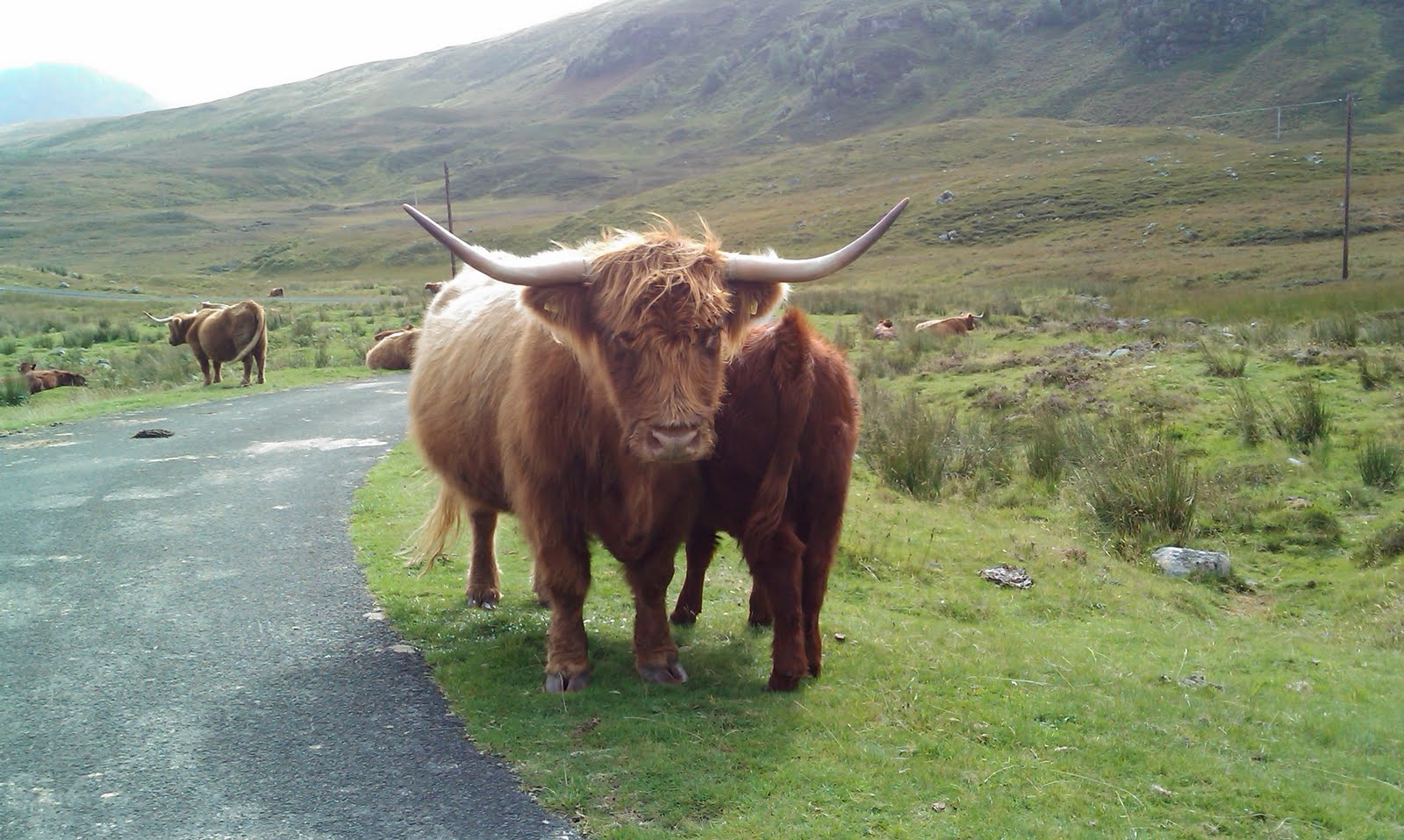
I eventually got to the dam wall of Loch na Daimh, parked up, got out of the car only to realise I was surrounded by yet more of the ginger docile beasts. The Meggernie Estate, to which the area belongs, has quite a herd.

I set off on the hike, passing below the dam wall and up onto the south bank of the loch. The path contoured around the hillside for a while before taking a sharp turn south and straight up the ridge of Creag an Fheadain, climbing about 400m in 1km. Pretty hard going, especially as the path up had a dual identity, also being a stream flowing down. Once this bit of hard climbing had been done the worst was over and the views east down the valley opened up.

The walk from here was pretty straight forward with a gentle climb up to Sron Chona Choirein and then a slight descent before following the ridge round to the final climb. Throughout this part of the walk I had great views to the south across Glen Lyon. The landscape was as though it was taken from a glaciology text book. The hanging valleys were perfect.

The final leg of the climb followed a broad sweeping shoulder before a short steep kick up to the summit. All the while I had a good view down the corrie to Lochan nan Cat (see first photo). The weather was starting to turn at this stage so I didn't hang around and covered the ground quickly.

The views from the top were awesome even though the weather was murky. To the west Ranoch Moor was in view, to the south Ben More, to the east Glen Lyon and to the south east the Ben Lawers ridge. The notch between An Stuc and Meall Garbh clearly shows how steep (and scary) the descent of An Stuc is.

The route back was the same as the way up. Once off the top the weather cleared and it was an enjoyable quick stroll back. This was the first hike I'd done with two trekking poles, which I used throughout. Once I got into the rhythm of using them I found them to be extremely useful. They certainly took some weight off my legs, meaning less soreness the next day and gave my arms some exercise too.
Once back at the car I needed to negotiate the Glen Lyon herd again. Another cow wouldn't move off the road and was quite happy to drive along side her, open my car window stroke her nose. The next cow laid down on her belly didn't really want to move from her comfortable pose either, with legs crossed in front on the tarmac. An excellent day and a great inspiration to visit this magical glen again.


Stat's
Distance: 9.36km
Ascent: 752m
Time: 3hours, 8 min
Munro count: 1
Total Munro count: 16 (of 283)

View Stuchd an Lochain in a larger map
Sunday 27 June 2010
Cruach Ardrain and Beinn Tulaichean
26th June 2010
A fantastic walk, up a beautiful glen and then some steep climbing and descending, all the time surrounded by magnificent mountains.
The contrast between today's hike and that of a couple of weeks ago up Schiehallion is vast. Where Schiehallion was like Blackpool prom on August bank holiday, I had these hills virtually to my self. Whilst Schiehallion has a soul destroying boulder field and a broad defined track, this route has challenging climbs and small paths that need to be sought out. Schiehallion sits on it's own, these 2 are surrounded by impressive peaks that you'll want to visit next.
It's possible to to do this walk starting from the north near Crianlarich. However, I've been wanting to take a look at Balquhidder and Loch Voil for a while so decided to approach them from the south. Balquhidder looks a pretty village, with a well known tea rooms (to visited with Mrs. Downs first) and the burial place of Rob Roy MacGregor. We'll certainly be visiting again. The drive along Loch Voil is fabulous and I was very tempted to stop off at Monachyle Mhor. I parked up at Inverlochlarig at 9am and was walking by 9:15.

The route started with a gentle stroll through Inverlochlarig farm and onto a farm track up into the glen of the same name. The farm certainly seemed to welcome walkers with helpful signs for all the paths to the various mountains in the area. They also have a farm door shop that sells probably the best venison I've had.

Following the track alongside the Inverlochlarig burn I noticed an area that had been fenced off around the river. This turned out to be a conservation area where they're trying to encourage the growth of native species and keep sheep and deer out that eat them.

After 3km or so I came to the end of the track and started to make my way across country up to the head of the stream. By this time I was completely surrounded by mountains, the two munros that I was about to climb, plus Stob Binnein on my right. The valley floor was green and lush, with many wild flowers around, almost reminding me of an Alpine meadow.

As I approached the boulder strewn bealach I was greeted with a clear uninhibited view of the whole western face of Ben More. An incredible sight seeing the whole mountain from valley floor to summit. Then from the summit the sweeping parabolic curve of the ridge down and then up to Stob Binnein. This glen and bealach have to be the most fabulous that I've enjoyed to date.

After a relatively gentle walk up to the bealach the route now took a sharp turn; to the left and up. The climb up on to Stob Garbh was really hard work. The air was still and a bit muggy. The heart rate soon climbed and the sweat started pouring! I climbed about 500m in 2 km at this point. From the top of Stob Garbh the views north to Crianlarich and the hills around Tyndrum were fabulous. The roads north to Glen Coe and Fort William and West to Oban were perfectly clear.

Stob Garbh stands at 959m (3146ft) but is not a munro. It's considered a munro top as it's part of the ridge that leads up to Cruach Ardrain. A Munro top is a summit over 3,000 ft which is not regarded as a separate mountain. I'm not entirely clear how the Scottish Mountaineering Club distinguish between a summit that is separate mountain. By the time I'd walked along the ridge and down into another bealach Stob Garbh seemed very separate from Cruach Ardrain.

The north east face of Cruach Ardrain loomed in front of me. To say it looked like a vertical climb with no obvious path would be putting it very simply! I found the very small and narrow path and stuck to it. This was real mountain goat territory, the sort of route that is fine going up until you look down. I certainly wouldn't have wanted to go down this side of the mountain. The joy of these sort of climbs is that though they're steep, they are straight up and you quickly reach your objective. The challenge is there, hold your nerve and the rewards are fabulous. In this case more great views north, back to Stob Garbh and beyond, east to Ben More and Stob Binnein and west to the Falloch Valley and An Caisteal. I stopped here for a drink and sandwich and enjoyed the vista.

Walking south the path along the ridge to Beinn Tulaichean was straight forward, but gave great views of summits still to be visited; An Caisteal and Beinn a' Chroin.

Now the hard work started. The descent off the hill side was extremely steep and hard going. My legs felt it the next day. This was tempered with views down Loch Voil though. As I reached the valley floor I spotted an impressive upright boulder with it's own tree.

I eventually regained the farm track and headed back to the car, but first stopped to buy some venison and have a chat with the farmer.
Stat's
Distance: 15.3 km (9.5 miles)
Ascent: 1987m (6571 ft)
Time: 5 hours, 56 min
Munro count: 2
Total Munro count: 15 (of 283)

View Cruach Ardrain in a larger map
A fantastic walk, up a beautiful glen and then some steep climbing and descending, all the time surrounded by magnificent mountains.
- Cruach Ardrainn (1046m) Krooerch Ardren, "High Stacked Heap"
- Beinn Tuliachean (946m) Bine Toolerchine, "Hill of the Little Green Eminence"
The contrast between today's hike and that of a couple of weeks ago up Schiehallion is vast. Where Schiehallion was like Blackpool prom on August bank holiday, I had these hills virtually to my self. Whilst Schiehallion has a soul destroying boulder field and a broad defined track, this route has challenging climbs and small paths that need to be sought out. Schiehallion sits on it's own, these 2 are surrounded by impressive peaks that you'll want to visit next.
It's possible to to do this walk starting from the north near Crianlarich. However, I've been wanting to take a look at Balquhidder and Loch Voil for a while so decided to approach them from the south. Balquhidder looks a pretty village, with a well known tea rooms (to visited with Mrs. Downs first) and the burial place of Rob Roy MacGregor. We'll certainly be visiting again. The drive along Loch Voil is fabulous and I was very tempted to stop off at Monachyle Mhor. I parked up at Inverlochlarig at 9am and was walking by 9:15.

The route started with a gentle stroll through Inverlochlarig farm and onto a farm track up into the glen of the same name. The farm certainly seemed to welcome walkers with helpful signs for all the paths to the various mountains in the area. They also have a farm door shop that sells probably the best venison I've had.

Following the track alongside the Inverlochlarig burn I noticed an area that had been fenced off around the river. This turned out to be a conservation area where they're trying to encourage the growth of native species and keep sheep and deer out that eat them.

After 3km or so I came to the end of the track and started to make my way across country up to the head of the stream. By this time I was completely surrounded by mountains, the two munros that I was about to climb, plus Stob Binnein on my right. The valley floor was green and lush, with many wild flowers around, almost reminding me of an Alpine meadow.

As I approached the boulder strewn bealach I was greeted with a clear uninhibited view of the whole western face of Ben More. An incredible sight seeing the whole mountain from valley floor to summit. Then from the summit the sweeping parabolic curve of the ridge down and then up to Stob Binnein. This glen and bealach have to be the most fabulous that I've enjoyed to date.

After a relatively gentle walk up to the bealach the route now took a sharp turn; to the left and up. The climb up on to Stob Garbh was really hard work. The air was still and a bit muggy. The heart rate soon climbed and the sweat started pouring! I climbed about 500m in 2 km at this point. From the top of Stob Garbh the views north to Crianlarich and the hills around Tyndrum were fabulous. The roads north to Glen Coe and Fort William and West to Oban were perfectly clear.

Stob Garbh stands at 959m (3146ft) but is not a munro. It's considered a munro top as it's part of the ridge that leads up to Cruach Ardrain. A Munro top is a summit over 3,000 ft which is not regarded as a separate mountain. I'm not entirely clear how the Scottish Mountaineering Club distinguish between a summit that is separate mountain. By the time I'd walked along the ridge and down into another bealach Stob Garbh seemed very separate from Cruach Ardrain.

The north east face of Cruach Ardrain loomed in front of me. To say it looked like a vertical climb with no obvious path would be putting it very simply! I found the very small and narrow path and stuck to it. This was real mountain goat territory, the sort of route that is fine going up until you look down. I certainly wouldn't have wanted to go down this side of the mountain. The joy of these sort of climbs is that though they're steep, they are straight up and you quickly reach your objective. The challenge is there, hold your nerve and the rewards are fabulous. In this case more great views north, back to Stob Garbh and beyond, east to Ben More and Stob Binnein and west to the Falloch Valley and An Caisteal. I stopped here for a drink and sandwich and enjoyed the vista.

Walking south the path along the ridge to Beinn Tulaichean was straight forward, but gave great views of summits still to be visited; An Caisteal and Beinn a' Chroin.

Now the hard work started. The descent off the hill side was extremely steep and hard going. My legs felt it the next day. This was tempered with views down Loch Voil though. As I reached the valley floor I spotted an impressive upright boulder with it's own tree.

I eventually regained the farm track and headed back to the car, but first stopped to buy some venison and have a chat with the farmer.
Stat's
Distance: 15.3 km (9.5 miles)
Ascent: 1987m (6571 ft)
Time: 5 hours, 56 min
Munro count: 2
Total Munro count: 15 (of 283)

View Cruach Ardrain in a larger map
Saturday 12 June 2010
Schiehallion
12th June 2010

Schiehallion (Scottish Gaelic: Sìdh Chailleann) The Fairy Hill of the Caledonians, 1083m
Some time last Autumn I made my first visit to Schiehallion with my nephews Hamish and George. Although we started off in good weather by the time we got to the boulder field the cloud had come down and the wind picked up. The boys weren't too happy so we turned back. So I've had this one on my list for a revisit throughout the winter. After Thursday's long walk above Loch Tay Schiehallion seemed just the job for today.

I got to the car park at about 10:45, I was expecting there to be quite few people around as it is a popular mountain. However the car park was full! I ended up parking on the side of the road. Looking up to the mountain I could see the quite a number of folk making their way, ant like, up the mountain.

I'm not really sure why Schiehallion is such a popular mountain. Sure it's got a great profile that has adorned many Scottish Tourism publications, but you don't see that when you're on the footpath. It's quite an isolated peak with no other munros immediately neighbouring. The path up to boulder field is excellent, thanks to the hard work of the John Muir Trust, who own half the land. After that it's really quite an unpleasant hike across an extensive boulder field. Reminds me of Scafell Pike, only longer. Once at the top there isn't much option but to go back down the way you've just come.
 Still, it does have an interesting history. The mountain was used in an 18th century experiment to determine the density of the Earth. Interesting fact for all the map geeks out there is that as part of this experiment it was first place to be mapped using contour lines.
Anyway, the hike up the path was quite enjoyable with extensive views behind to Loch Tummel. It was pretty steep in places and the legs were still tired from last Thursday, so I broke it down into 50m climb chunks. Every 50m elevation gained (checking on my old running GPS) I would stop and take a break. Within an hour I had reached the top of the path and the beginning of the boulder field. I then picked out a route across the rock strewn plateau to the first big cairn. This was as far as we had got last time. Looking ahead I realised that there was still quite a way to go to the summit, so the decision to turn back last year was a good one.

The trek to the summit felt like Princess Street on the last Saturday before Christmas. Once at the top groups of people were changing into their charity t-shirts ready for the group photos, other people were sat beside the summit cairn on their mobile phones; "We're at the top of Schiehallion, did you remember to turn the iron off? blah, blah" etc. I took a few snaps looking across Ben Lawers and it's neighbours, but didn't hang around. The walk back across the boulder field seemed easier on the way back and I was soon back to the main path. The down was quick and I was back in the car park within 3 hours.

Stat's
Distance: 10.62km (6.6 miles)
Ascent: 902m (2960 ft)
Time: 2 hours 59 mins

View Schiehallion in a larger map
Friday 11 June 2010
The Ben Lawers 5
10th June 2010.

This was first big ridge walk that I've done covering 5 Munros in total and taking me into double figures on the overall count (12 out of 283):
Beinn Ghlas (Bine Glaz) 1103m
Ben Lawers 1214m
An Stuc (Un Stook) 1118m
Meall Garbh (Miaowl Garav) 1118m
Meall Greigh (Miaowl Gree) 1001m
I've had this one on my to do list for quite a while, but wanted a midweek day to do it with a hope for fewer people. When going up Meall Corranaich a couple of weeks ago I noticed a large number of people heading up the ridges line. I wanted to avoid the crowds, so with a week off in June I checked the weather and picked what was looking to be the best day. Boy! it was a great day, but a hard one.
I left the Ben Lawers visitors centre (now closed, though the National Trust still ask for some parking money) at 9:30 and had an enjoyable stroll through the nature reserve. There were many beautiful wild flowers out, I wish I knew the names of them. Leaving the nature reserve the path kicked up onto the ridge leading to Beinn Ghlas. To the left of me Meall Corranaich was soon in clear view and Meall nan Tarmachan behind me. Great views to Loch Tay and Ben Vorlich to the south as well.
A few people could be spotted ahead of me. One of which was National Trust guy with a spade. He was clearing all the cross path drainage channels - really scrapping a living from the mountains! From the top of Beinn Ghlas the path onwards to Ben Lawers and beyond could easily be picked out, though the summit was covered in cloud. The path between Beinn Ghlas and Ben Lawers was very straight forward and soon the summit cairn and trig point came into view. The cloud had lifted too! The views north from the summit (my highest so far and 10th highest munro) were awesome. I think I could pick out Ben Nevis in the far distance.
Not hanging around too long I started down to the bealach before An Stuc. Fabulous views of Lochan nan Cat. I heard quick moving footsteps behind me and managed to step to one side just in time to let a crazy fell runner go speeding by in just a vest, running shorts and trainers. Don't know how those lads do it. An Stuc was a pretty steep, but enjoyable climb and summit made a perfect, wind free lunch stop, plus munro number 10. The views were extensive in all directions. Whilst exhilarating, it was also humbling; such a vast area of upland and so many mountain peaks to visit. Munro bagging maybe just a tick list of mountain summits visited, almost like a train spotter collecting numbers, but it does give some direction on where to travel in such a large area.
The descent off An Stuc was described in the guide book as being a tricky scramble. Sure enough it was pretty unpleasant and needed both hand to be used in some difficult spots. Not particularly enjoyable at the time. Heading up Meall Garbh and looking back onto An Stuc it was impossible to pick out the footpath.

From the top of Meall Garbh there were some great views back to the previous 3 summits. Looking east I could see the final summit; Meall Greigh. Quite a different mountain with more of a rounded profile. It also looked an awful long way away. It was! By this time the legs were pretty tired and trek across became a real trudge. It was worth it though as the view from the summit back to the ridge was astounding. The middle 3 summits, coire and lochan all in splendid view.

There was no defined path from Meall Greigh, just a trundle down the hillside heading for a small dam. From there much of the route home was along a pretty boring farm track. This again was a trudge, but views of Loch Tay made up for it. At the point where the route left the track I met up with the chap that had been in front of me all day. Paul had driven up from Bristol the day before and was trying to get as many peaks in before his return south the next day. Makes me realise how lucky I am to have all this on the doorstep. Paul and I walked the final stretch back to the visitors centre. This was a real slog and seemed to go on forever. Just under 8 hours later we were back at the cars, both exhausted and in need of a drink!
A truly great day out in the mountains, but knackering!
Distance: 22.77km (14.15 miles)
Total ascent: 1932m (6340ft)
Time: 7hours 35min

View BenLawers in a larger map
Subscribe to:
Posts (Atom)
